
Ruidoso, a picturesque village nestled in the mountainous terrain of southern New Mexico, is currently navigating an unprecedented and devastating confluence of natural disasters. This scenic community, home to nearly 8,000 residents, has been battered first by two massive wildfires in June, followed by a relentless series of flash floods cascading down the denuded mountainsides. The catastrophic sequence of events has claimed lives, destroyed hundreds of homes, and laid bare the intensifying risks faced by communities in the American West as climate change accelerates extreme weather patterns.
A Community Under Siege: The Immediate Crisis
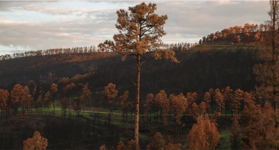
The initial onslaught began in mid-June with the rapid ignition and spread of two major conflagrations: the South Fork Fire and the Salt Fire. These blazes erupted along the mountains encircling Ruidoso, quickly scorching over 25,000 acres of pristine forest and forcing the mandatory evacuation of the entire village. The fires, fueled by hot, dry conditions and dense vegetation, moved with terrifying speed, leaving behind a trail of destruction that included nearly a thousand residential structures and claiming the lives of two individuals. The smoke-choked skies and the orange glow of the advancing flames cast a pall of uncertainty over the region, as firefighters from multiple agencies battled valiantly to contain the inferno.
Even as containment efforts progressed and some residents began to cautiously consider their return, a new and equally destructive threat emerged. Beginning on June 21st, and recurring with alarming frequency at least eight times since, including a significant event this past Saturday, torrential floodwaters have surged through the village. These deluges are a direct, and scientifically predicted, consequence of the wildfires, which stripped the landscape of its protective vegetation and fundamentally altered the soil composition. The mountainsides, once verdant and capable of absorbing rainfall, have been transformed into barren, hydrophobic surfaces, effectively funneling massive volumes of water, ash, and debris directly into the valleys below.
Chronology of a Dual Disaster
The genesis of Ruidoso’s predicament can be traced back to the prolonged drought conditions that have plagued much of the American Southwest for years. New Mexico, like its neighboring states, has experienced increasingly warmer temperatures and reduced precipitation, creating ideal conditions for severe wildfires. Forests, already stressed by drought and susceptible to insect infestations, accumulate vast amounts of dry fuel, turning them into tinderboxes.
The Wildfire Onslaught (Mid-June 2024):
- June 17: The South Fork Fire was reported, originating on the Mescalero Apache Reservation near Ruidoso. Simultaneously, the Salt Fire also ignited in the same vicinity. Initial reports suggested human causes for at least one of the fires, though investigations are ongoing.
- June 18-19: Fueled by strong winds, high temperatures exceeding 90 degrees Fahrenheit, and extremely dry conditions, both fires exploded in size. The South Fork Fire rapidly grew, pushing towards Ruidoso, while the Salt Fire expanded eastward. The rapid progression prompted immediate and widespread evacuation orders for Ruidoso and surrounding areas, including parts of the Mescalero Apache Reservation. Thousands of residents were forced to flee with little notice, seeking shelter in neighboring communities.
- June 20-25: Firefighting resources from federal, state, and local agencies converged on the area. The South Fork Fire eventually consumed over 16,000 acres, destroying an estimated 1,400 structures, predominantly homes, within and around Ruidoso. The Salt Fire burned over 8,000 acres, contributing to the overall devastation. Tragically, two fatalities were confirmed as a direct result of the fires, underscoring the lethal speed and intensity of the blazes. Power outages and infrastructure damage were extensive, complicating emergency response and recovery efforts.
- Late June: As firefighters began to achieve greater containment, residents were cautiously allowed back into portions of the village, only to face the overwhelming reality of widespread destruction. The landscape left behind was scarred, with vast swathes of forest reduced to ash and charred remains.
The Deluge Begins (Late June – July 2024):
- June 21: Just days after the fires raged, the first significant post-wildfire rain event struck. This marked the beginning of New Mexico’s typical monsoon season, which usually brings intense, localized thunderstorms from late June through September. However, with the burn scars fresh, what would normally be manageable rainfall quickly transformed into destructive flash floods.
- Subsequent Weeks (July): Throughout July, a series of at least eight distinct flash flood events inundated Ruidoso. These included significant incidents that closed roads, damaged already weakened infrastructure, and threatened homes that had miraculously survived the fires. The floodwaters carried massive amounts of ash, mud, rocks, and charred timber, creating debris flows that carved new channels and choked existing drainage systems. Each new storm reignited fears and compounded the challenges for residents attempting to assess damage or begin rebuilding. The most recent major flood, occurring this past Saturday, served as a stark reminder that the danger remains acute and ongoing.
The Science of Burn Scars and Supercharged Floods

The devastating floods in Ruidoso are not merely coincidental events following the fires; they are a direct and scientifically predictable consequence of the altered landscape. Wildfires fundamentally change the hydrology of a watershed in several critical ways:
- Vegetation Loss: Trees, shrubs, and ground cover act as natural sponges, intercepting rainfall, slowing its descent, and allowing it to percolate into the soil. When this vegetation is incinerated, rainwater hits the bare ground directly.
- Soil Hydrophobicity: Intense heat from wildfires can bake the soil, creating a waxy, water-repellent layer known as a hydrophobic layer. This phenomenon dramatically reduces the soil’s ability to absorb water, turning it into a non-porous surface. Andrew Mangham, a hydrologist with the National Weather Service, aptly described this effect, stating it was "as if giant plastic sheets had been draped on the mountains, then covered with ash and tree trunks that would tumble down at the slightest invitation."
- Increased Runoff: With no vegetation to slow it and hydrophobic soil to absorb it, rainfall rapidly flows across the surface. This dramatically increases the volume and velocity of runoff, leading to flash floods that are far more powerful and destructive than those in unburned areas.
- Debris Flows: The fast-moving water picks up loose ash, soil, rocks, and charred logs, transforming into highly destructive debris flows or mudslides. These flows can easily sweep away vehicles, destroy bridges, and bury homes.
The elevated risk of flash floods and debris flows in burn scars can persist for more than five years, or until significant vegetation regrows and soil structure recovers. This means Ruidoso and other communities affected by similar disasters face a prolonged period of vulnerability, requiring continuous monitoring and preparedness.
Official Responses and Community Resilience
In the face of this unprecedented dual disaster, local, state, and federal agencies have mobilized extensive resources. The initial wildfire response involved multiple incident management teams, thousands of firefighters, and air support from the U.S. Forest Service, New Mexico State Forestry Division, and local fire departments. Evacuation centers were established in nearby towns, providing shelter and resources for displaced residents.
New Mexico Governor Michelle Lujan Grisham declared a state of emergency for Lincoln County and the Mescalero Apache Reservation, rapidly deploying state resources and facilitating requests for federal assistance. The Federal Emergency Management Agency (FEMA) has been involved, offering support for disaster relief and recovery efforts, though the full extent of federal aid will depend on further declarations and assessments. The National Weather Service has played a crucial role in issuing timely flood watches and warnings, utilizing specialized hydrologic models to predict areas of highest risk within the burn scars.
For the residents of Ruidoso, the emotional and practical toll has been immense. Many have lost everything to the fires, only to see their remaining property or the roads leading to their homes damaged by floods. The uncertainty of recovery, coupled with the ongoing threat, has created a profound sense of anxiety. Yet, the community has also demonstrated remarkable resilience. Volunteer organizations, aid groups, and neighboring communities have rallied to provide assistance, from temporary housing and food to emotional support and cleanup efforts. The economic impact on Ruidoso, a town heavily reliant on tourism, is also a significant concern, with the summer season severely disrupted.
Broader Implications: Climate Change and the Future of the American West
The Ruidoso disaster serves as a stark illustration of a "worst-case scenario" that climate scientists warn may become increasingly common in the American West. The confluence of extreme wildfires and subsequent severe rainfall events is a signature impact of a warming planet:
- Fiercer Wildfires: Climate change contributes to hotter, drier conditions that lengthen fire seasons and increase the intensity and frequency of large-scale wildfires. Warmer temperatures lead to more rapid desiccation of vegetation, turning landscapes into more volatile fuel sources.
- Intensified Storms: A warmer atmosphere holds more moisture. For every 1 degree Celsius increase in temperature, the atmosphere can hold approximately 7% more water vapor. This can lead to more intense precipitation events, especially during monsoon seasons or when atmospheric rivers make landfall, exacerbating flood risks, particularly over burn scars. The phenomenon of severe rainfall following wildfires is a well-documented hazard, with studies consistently linking increased fire activity to heightened flood and debris flow risks in a changing climate.
This escalating threat necessitates a fundamental shift in land management, urban planning, and emergency preparedness strategies across the region. Communities in fire-prone and flood-vulnerable areas must:
- Enhance Forest Resilience: Implement aggressive forest thinning, prescribed burns, and other fuel reduction treatments to create more resilient landscapes that are less susceptible to catastrophic wildfires.
- Improve Infrastructure: Invest in resilient infrastructure design, including upgraded culverts, stormwater management systems, and debris basins, specifically engineered to withstand post-fire flood events.
- Develop Advanced Warning Systems: Utilize and invest in sophisticated weather forecasting and hydrological modeling tools to provide earlier and more accurate warnings for flash floods in burn scar areas.
- Re-evaluate Building Codes and Land Use: Consider stricter building codes and updated land-use planning that account for increased fire and flood risks, potentially restricting development in the most vulnerable zones.
- Foster Community Preparedness: Educate residents on evacuation procedures, emergency kits, and the unique dangers of post-fire flooding, encouraging individual and community-level preparedness.
The long-term recovery for Ruidoso will be a multi-year endeavor, encompassing not just rebuilding homes and infrastructure but also ecological restoration of the damaged watersheds and the psychological healing of a community deeply scarred by these successive catastrophes. The tragic events in Ruidoso stand as a powerful and urgent reminder of the interconnectedness of climate impacts and the critical need for proactive adaptation and mitigation strategies as the American West navigates an increasingly volatile future.